
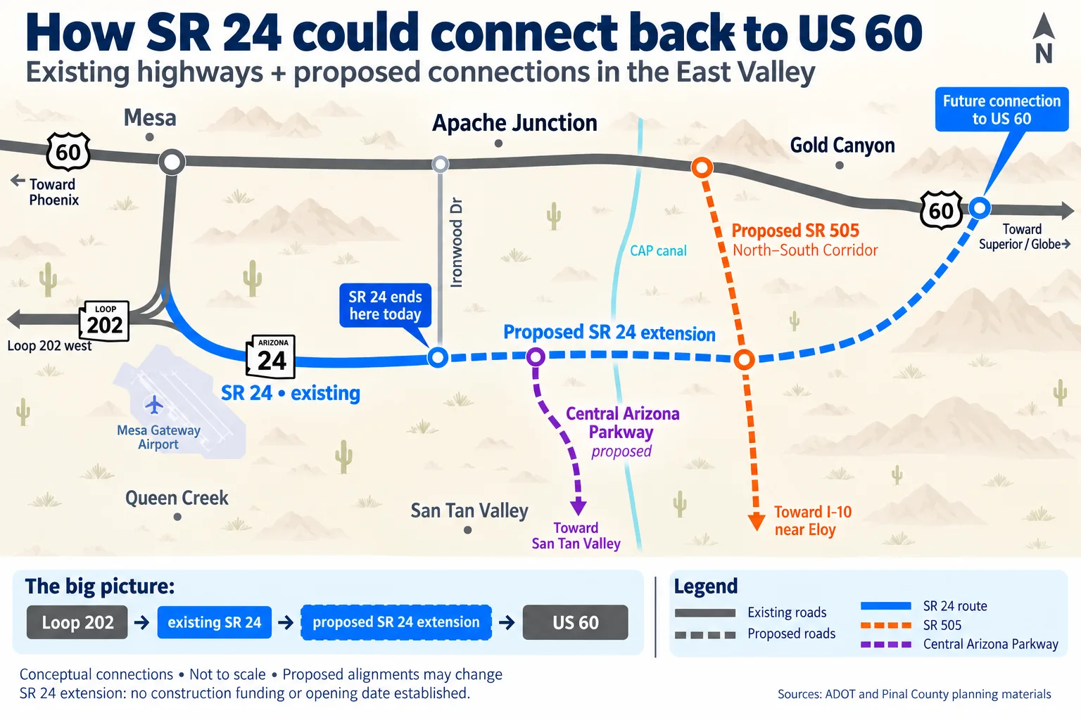
Imagine leaving Loop 202 near Mesa Gateway Airport and staying on SR 24 all the way to US 60. Instead of reaching the end of the highway at Ironwood Drive, you would continue east through northern Pinal County, pass connections to two other planned roads and eventually rejoin US 60 beyond the existing East Valley freeway network.
That is the long-range vision behind the SR 24 extension to US 60. For drivers in southeast Mesa, Queen Creek, San Tan Valley and Apache Junction, the proposal is about more than a longer highway: it could create new choices for moving across a growing region.
As of September 20, 2026, the crucial distinction is timing: improvements to the existing SR 24 are moving toward construction, while the eastern extension remains an unfunded proposal with no established opening date.
What the future SR 24 route could look like
Follow the blue line in our map from west to east. At Loop 202, SR 24 curves southeast alongside the Mesa Gateway Airport area before straightening east toward Ironwood Drive. The dashed section shows the proposed continuation.
Loop 202 to Ironwood Drive: the existing highway and the starting point for the larger network.
East of Ironwood: a future extension would connect with Central Arizona Parkway, a separate road proposed to run south toward San Tan Valley.
Across the CAP canal: SR 24 would continue toward an interchange with the proposed SR 505 North–South Corridor.
Onward to US 60: the longer-range route would continue east and bend toward a connection with US 60 in the broader Gold Canyon area.
The exact alignment and interchange locations remain subject to planning and design. This would be a new eastward corridor; it would not simply route SR 24 north along Ironwood Drive.
About the hero image: This AI-assisted East Valley Explorer illustration explains conceptual connections. It is not an official ADOT alignment map, is not to scale and should not be used to determine impacts on a particular property. Solid lines show existing roads; dashed lines show proposals.
What is coming first: upgrades to the existing SR 24
ADOT’s current SR 24 project covers Loop 202 to Ironwood Drive. The agency says design was completed in spring 2026 and construction is anticipated in early 2027.
Plans call for two additional lanes in each direction between Loop 202 and Williams Field Road, and one additional lane each way from Williams Field to Ironwood. Bridges at Williams Field, Crismon, Signal Butte and Meridian roads would separate highway traffic from cross streets. Ironwood would receive a diverging diamond interchange.
The work also includes selected Loop 202 lane additions and new connector ramps between Ellsworth Road and Loop 202. Proposition 479 transportation sales-tax revenue provides part of the funding. These improvements would change how the existing corridor operates; they do not deliver the extension to US 60.
SR 505: the proposed north–south freeway
The orange route on the map is SR 505, also called the North–South Corridor. ADOT describes a planned 55-mile route from US 60 in Apache Junction to I-10 near Eloy, with a future connection to SR 24.
That intersection is what makes the network especially interesting. SR 24 would provide an east–west connection, while SR 505 would open a north–south path through Pinal County. Together, they could offer routes unavailable on today’s freeway map.
A broad corridor was selected in 2021. More detailed environmental and engineering studies are refining the alignment and interchange locations. ADOT says there is currently no construction timeline and no identified funding for design, right-of-way or construction. A selected study corridor is an important planning step, but it does not mean construction is imminent.
Central Arizona Parkway: a separate connection toward San Tan Valley
The purple line represents Pinal County’s Central Arizona Parkway project. It is separate from SR 505 and would connect with the SR 24 extension west of the proposed north–south freeway.
The county describes an initial four-lane parkway extending south toward the Ocotillo Road alignment, with access at Germann and Ocotillo roads. A continuation toward Arizona Farms Road is also being evaluated.
For residents, the distinction matters: Central Arizona Parkway is intended to serve a different corridor from SR 505. The two names should not be treated as interchangeable, and the projects do not share one guaranteed construction schedule.
Why reaching US 60 is more complicated than drawing a line
Pinal County’s Central Arizona Parkway design concept report describes the SR 24 extension in two broad phases: first from Ironwood toward the Central Arizona Project canal, then across the canal and flood-control facilities toward US 60.
Those crossings require substantial bridges and earthwork. The report identifies them as a reason the later phase would be more expensive. On a simplified map, the extension looks like one continuous blue line. Delivering it would involve multiple engineering, funding and construction decisions.
What this could mean for East Valley drivers
If the full network is built, a trip from the Gateway area toward Superior or Globe could follow SR 24 east to US 60. SR 505 could provide another north–south option, while Central Arizona Parkway could help connect San Tan Valley to the extended corridor. Those are potential travel patterns, not promised commute-time savings.
The practical questions to watch next are straightforward: Where will final interchanges go? Which segments receive construction funding? When do agencies announce contracts and start dates? A study milestone answers a different question from an opening date.
For now, the clearest near-term change is the planned modernization of today’s SR 24. The larger vision remains a connected network stretching beyond Ironwood—one that could reshape how the East Valley and northern Pinal County fit together.
For more on the area around the corridor, explore our guides to Eastmark and Cadence at Gateway, plus our reporting on Legacy Park in Mesa.
